|
METRIC | IMPERIAL
|
Updated: Aug-14-2018 @ 9:10pm
|
| Temperature |
Current Conditions |
Forecast / Storm Prediction |
Currently Outside: 
79.2°F
Feels like: 83°F
---
|
High Today
91.2°F
1:06 PM |
Low Today
72.7°F
5:29 AM |
Yest High
88.0°F
2:17 PM |
Yest Low
72.7°F
6:26 AM |
Sta* High
93.2°F
2016 |
Sta* Low
63.4°F
2015 |
| * This Station's Records Since 6/2000 |
Rec* High
93°F
1995 |
Rec* Low
63°F
1950 |
| * Records from Weather Underground |
|
|
|
 |
Night time, Humid, Clear skies
|
 |
Wind: S
0.4
Gusting to:
0.0 mph |
 |
Rain:
0.00 in |
 |
Current CBI
Fire Danger:
0.1 of 100
|
|
|
| Dew Point |
Liquid Precipitation |
Wind Speed |
Sun/Moon |
| Current: |
74.6°F |
| Last Hour: |
0.6°F |
| High 2:12 PM: |
79.7°F |
| Low 2:55 AM: |
72.6°F |
| Record High: |
125.8°F on
Dec-10-2017 |
| Record Low: |
0.9°F on
Jan-11-2018 |
| Wetbulb: |
76.0°F |
|
Rain Today
|
| Today: |
0.00 in |
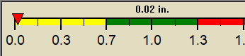
| Yesterday: |
0.02 in |
| Last 7 Days: |
0.92 in |
| Aug Rain: |
3.36 in |
Aug to Date
Avg:10 |
3.32 in |
Aug to Date
Diff from Avg:10 |
 0.04 in 0.04 in |
| Aug Avg: |
6.66 in |
| Diff from Avg: |
3.30 in |
| Season:1 |
42.371 in |
YTD
Avg:11 |
33.07 in |
YTD
Diff from Avg:11 |
9.30 in |
Last Rain
Time/Date: |
Aug-13-2018
at 2:40 PM |
| 99 rain days in 2018 |
10 days in August
0 days since last rain |
|
| Current: |
S 0.4 mph |
| 1Hr Average: |
1.7 mph |
| Wind Run: |
24.34 miles |
| Wind Gust |
| Current: |
0.0 mph mph |
| Today: |
15.4 mph 3:20 PM |
| Month: |
22.0 mph Aug-2 |
| Year: |
70.2 mph Apr-24 |
| Record Gust: |
89.7 mph
Sep-27-2011 |
|
13 hrs 25 mins 49 secs
of daylight today
|
NOON
MIDNIGHT

|
1 minute and 49 seconds
shorter than yesterday |
| Evening Crescent |
 |
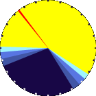
20%
Illuminated |
|
| Humidity |
Barometer |
| Current: |
86% |
| Last Hour: |
1% |
| High 12:40 AM: |
100% |
| Low 1:14 PM: |
58% |
| Record High: |
100%
Oct-5-2000 |
| Record Low: |
0%
Jan-23-2016 |
|
| Current: |
30.052 inHg |
| Last Hour: |
Steady |
| High 8:21 AM: |
30.057 in. |
| Low 4:35 AM: |
30.010 in. |
| Record High: |
30.977 inHg
Dec-15-2001 |
| Record Low: |
25.502 inHg
Aug-8-2017 |
|
| Cooling Degree Days |
Tide |
Heat Index |
Air |
| Today: |
10.4 |
| Aug: |
269.4 |
| 2018 to Date: |
1477.5 |
| Heating Degree Days |
| 2018 to Date: |
1224.4 |
|
|
4 hours, 22 minutes to high tide at
12:19 PM EDT

|
|
| Current: |
83.3°F |
| High 1:06pm: |
108.1°F |
| Yesterday: |
102.8°F |
| Record: |
126.3°F
Jun-20-2018 |
|
Quality
Index6:
52

Density:
1.17 kg/m3 |
|
| UV Summary/Forecast |
Solar Summary |
|
|
High Today:
1005 W/m2 @ 1:26 PM |
Sun Hours Today:
03:06
This Month: 47:53 Hrs |
| Rise: 6:35 am Set: 8:02 pm |
|
| Almanac |
Support this Site! |
Station All Time Records |
Muggy Meter |
| Currently: |
Evening |
| YTD Avg Temp: |
66.5°F |
| Sunrise: |
6:35:53 AM |
| Sunset: |
8:01:42 PM |
| Moonrise: |
11:06 am |
| Moonset: |
10:28 pm |
| Full Moon: |
Aug-26-2018 |
| New Moon: |
18:02 UTC
Sep-9-2018 |
|
Your donation helps support this site |
|
| HIGHS: |
LOWS: |
101.1°F
Jul-11-2015 |
9.3°F
Jan-11-2011 |
| Daytime Records |
105.8°F
Aug-08-2001 |
16.5°F
Jan-05-2001 |
| Nitetime Records |
94.6°F
Jul-13-2011 |
14.2°F
Jan-05-2001 |
ICN:1 | S3C2:2 ajaxWDwx3.js
ISS:Ok | CON:4.7 | RCP:99% |
|
Miserable |